
MCNY Blog: New York Stories
Iconic photos of a changing city, and commentary on our Collections & Exhibitions from the crew at MCNY.org
Forgotten villages and neighborhoods of Manhattan
Hints about long vanished and forgotten aspects of New York surround us if we know where to look. The etymology of neighborhood names reveal long lost geographical quirks and the powerful men who have faded from memory but whose names are still spoken on a daily basis on the land they used to own.
For instance, Greenwich Village was a separate town from the rest of New York and was named after the plentiful pine forest that in Dutch was “Greenwijck,” and was later anglicized as Greenwich. Kips Bay and Murray Hill were named for the original owners of the land, Jacobus Hendrickson Kip and Robert Murray respectively (the Hill in Murray’s land was at 36th Street and Madison; it has long since been flattened). Chelsea was the name of the manor of British Major Thomas Clarke, built almost 30 years before the American Revolution and in turn named after Sir Thomas More’s estate in London.
While knowing the history of current neighborhoods might help you out at an awkward cocktail party, what’s even cooler is knowing the history of neighborhoods that have been lost through absorption into other neighborhoods, a change in the economic landscape, or even slum clearing; Little Syria, Weeksville, Seneca Village, Crow Hill, Kleindeutschland, Tubby Hook, the Piggery District, and the infamous Five Points have all disappeared from the maps, and in some cases the memory, of New York.
In the 1850’s Bloomingdale (now the Upper West Side) was dotted with the country homes of wealthy citizens interspersed with small farming communities. It was a bucolic and beautiful area.
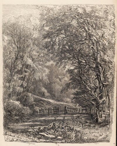
Eliza Greatorex (1819-1897). Howland Lane, 86th St, Bloomingdale. 1868. Museum of the City of New York. 35.408.30.
At that time New York City proper was overcrowded, rife with yellow fever, expensive, and dangerous. Intrepid New Yorkers began to realize that they could move to the wilds of Upper Manhattan and create a better life for themselves. Thanks to a burgeoning public transportation system, they would be able to get to Lower Manhattan easily. (At least that was what this 1870 article in the New York Times argued.)
One of these small communities was Carmansville, located between 142nd and 158th Streets from the Hudson River to Broadway (according to the Iconography of Manhattan by I.N. Phelps Stokes Vol. 6 pg. 654) in present-day Washington Heights. It developed because it had a train stop on the Hudson River Railway at the foot of 152nd Street. But the biggest draw was the natural beauty of the area. According to Resolvid Gardner, speaking to the New York Times in 1909, 1860’s Carmansville was the destination for picnickers and other pleasure seekers who would spend the afternoon fishing in the Harlem River catching boatloads of crabs.
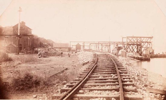
Paul Oscanyan. Carmansville and Hudson River. ca. 1885. Museum of the City of New York. X2010.11.3802.
Carmansville even had its own fire department.
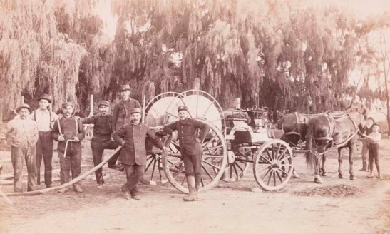
Paul Oscanyan. Carmansville Fire Department. ca. 1891. Museum of the City of New York. X2010.11.9135.
The most famous inhabitant of Carmansville was the naturalist and painter John Audubon whose estate, Minniesland, was at the foot of 156th Street.
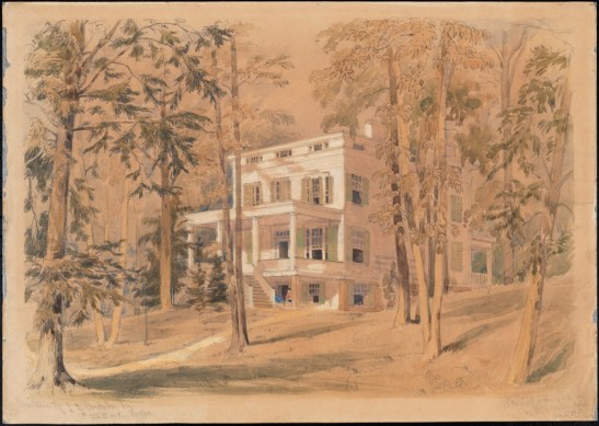
William Rickarby Miller. Residence of J. J. Audubon Esq. 1858. From J. Clarence Davies Collection of the Museum of the City of New York. 34.100.41.
The only remaining hint that Carmansville ever existed is a playground bearing its name on 152nd Street at Amsterdam Avenue.
Just eighty blocks downtown was the Harsenville community. Founded by the Harsen family in 1763 at the area now bordered by approximately 81st Street to 68th Street, from the Hudson River to Central Park West. During its heyday it had approximately 500 residents in about 60 buildings and boasted its own grocers, blacksmiths, and a village school. The center of the community was the Harsen homestead at 72nd and Broadway.
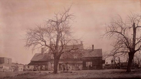
Unknown. Harsen Homestead, 72nd Street. ca. 1888. Museum of the City of New York. X2010.11.6166.
The march of modernity, however, was an ever-present threat to the future of both Harsenville and Carmansville, as this illustration from Harper’s Weekly shows.
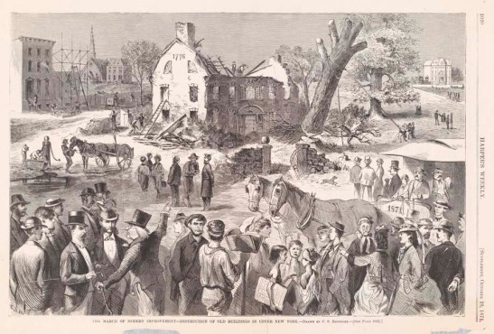
Charles Stanley Reinhart (1844-1896). The March of Modern Improvement – Destruction of Old Buildings in Upper New York. 1871. Museum of the City of New York. 55.53.2.
Starting in the early 1870’s, the Harsens began selling their land and within just a few decades, what was a rural farming community was absorbed into the constant development that created the Upper West Side. The one remaining hint that it ever existed? The Harsen House condominium built in 1938 on 72nd Street.

Peremptory Sale. Harsen Estate. 1873. Museum of the City of New York. 43.116.11A.
New York history is nothing if not cyclical. Fifty years later just south of where the Harsens lived was a tenement-filled area known as San Juan Hill (forever immortalized as the place where the fictional Tony and Maria fell in love in West Side Story). Instead of being named after the large Puerto Rican population that lived in the area, the name may refer to the influx of African American veterans who moved into the neighborhood after the Spanish American War or the frequent interracial street brawls. In 1940 the New York City Housing Authority characterized the area as “the worst slum section in the City of New York.” The entire neighborhood was razed to make way for Lincoln Center, but not before the movie version of West Side Story filmed the Sharks and the Jets rumbling in the old neighborhood.
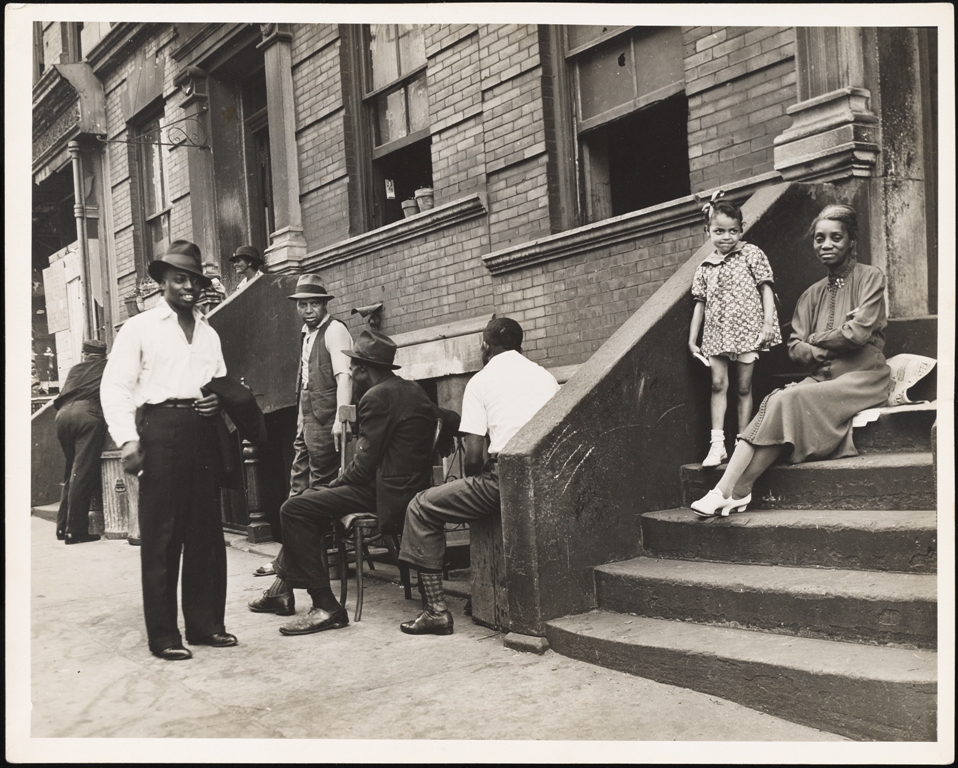
Lee Sievan (1907-1990). San Juan Hill. 1939. Museum of the City of New York. 92.70.1.
The same basic story took place on the East Side between 14th and 23rd Streets from 1st Avenue to the East River.

Large & Peremptory Sale of 79 Desirable Building Lots on 16th, 17th, 19th, 20th, and 21st Streets, and on Avenue B, 1852. 1852. The J. Clarence Davies Collection at the Museum of the City of New York. 29.100.3348.
The first massive gas storage tank was installed in 1843 on the land that was once Peter Stuyvesant’s farm; many more soon followed. As tends to happen, the gas tanks began to leak, emitting a noxious odor and earning the neighborhood the moniker Gashouse District. Beyond the smell, the neighborhood was run by the creatively-named Gashouse Gang, who, according to Herbert Asbury’s endlessly entertaining Gangs of New York, “averaged around 30 holdups a night.” In short, it was not a desirable place to be, so of course the rents were cheap and the area became the first stop for recent immigrants.
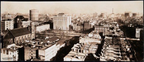
Wurts Bros. (New York, N.Y.) Elevated view of Stuyvesant Square and surrounding neighborhoods. ca. 1920-1935. Museum of the City of New York. X2010.7.2.23509.
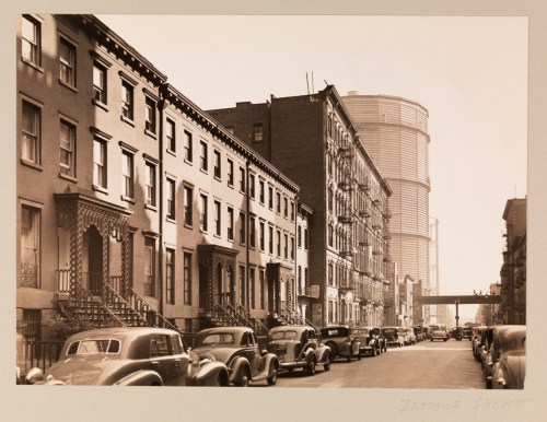
Berenice Abbott (1898-1991). Twentieth Street between Second and First Avenues. 1939. Museum of the City of New York. 40.140.264.
By the 1940’s the old Gashouse District was fading and the criminals and underworld figures who were so ingrained in the streets were curtailed (slightly) by the construction of the FDR Drive. In 1945 3,000 residents were relocated to Upper Manhattan. And then 600 tenement buildings, three churches, and two theaters were razed to create Metropolitan Life’s idyllic suburban paradise Stuyvesant Town and Peter Cooper Village for returning veterans.
Saving the most historic for the end, we have Cherry Hill. Located in what is now called Two Bridges, or more broadly the Lower East Side. In the 1700’s this was one of the most fashionable districts of New York. Old money families had mansions on streets lined with cherry trees. It was so classy that George Washington lived at Number 1 Cherry Street during the first term of his presidency.
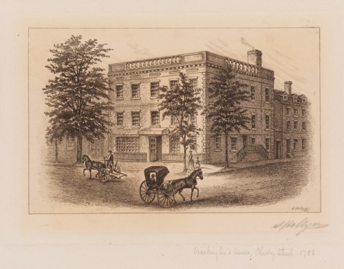
Samuel Hollyer (1826-1919). Washington’s House, Cherry Street, 1788. 1901. Museum of the City of New York. X2011.5.38.
But by the 1840’s Cherry Hill, and Cherry Street in particular, was home to one of the worst tenements in New York. Gotham House was home to over 1,000 people living in terrible conditions. For all the lurid details and horrifying mortality rates, read this New York Times article.
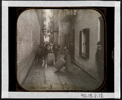
Jacob A. (Jacob August) Riis (1849-1914). Gotham Court, 38 Cherry Street — Double and Single Alley. ca. 1890. Museum of the City of New York. 90.13.2.12.
After Jacob Riis highlighted the horrors of Gotham Court in his expose How the Other Half Lives, the building was torn down. Constrained and isolated by both the Manhattan and Brooklyn Bridges and by the opening of the FDR Drive in the 1940’s, the neighborhood became the home of the Alfred E. Smith public houses honoring the former governor who grew up nearby.
Neighborhoods are constantly evolving in New York. Even now, you can’t go online without someone lamenting the death of an area. Between gentrification and constantly rising rents it seems like a modern problem, but really it’s been happening for the past 400 years.
About Susannah Broyles
4 comments on “Forgotten villages and neighborhoods of Manhattan”
Leave a comment
Museum of the City of New York


Great article, thanks! I’ve been looking at East Harlem, roughly 116th to 128th Streets, from 1850 to 1900, for my family history. It’s hard to comprehend what was happening. MCNY’s online collection has some photos, like on of “Halk’s Cottage” in 1900, that have been very helpful.
Pingback: John Bute Holmes, surveyor and polygamist. | mcnyblog
Pingback: Clement Clarke Moore and Santa in the City | MCNY Blog: New York Stories
Pingback: The Legendary Carmansville, The Most Beautiful, Picturesque Hamlet In Harlem, NY, 1853-